 GeoRefImg 2.5
AutoCAD plugin that supports georeferencing of raster images in plain AutoCAD
Last update
3 Feb. 2012
Licence
Free to try
OS Support
Windows XP
Downloads
Total: 3,682 | Last week: 22
Ranking
#22 in
3D Modeling & CAD
Publisher
Cad Studio A.s.
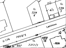
Screenshots of GeoRefImg

GeoRefImg Publisher's Description
Georeferencing of raster images in plain AutoCAD. GeoRefImg is a LISP utility which automatically repositions raster images used in a drawing to the position defined in the images' World files. World files define geo-position and other parameters of a raster image (TIF, CIT, JPG, PNG, GIF, BMP, ECW, SID...). For AutoCAD 2012, 2011, 2010.
Look for Similar Items by Category
Feedback
- If you need help or have a question, contact us
- Would you like to update this product info?
- Is there any feedback you would like to provide? Click here
Beta and Old versions
Popular Downloads
-
 Kundli
4.5
Kundli
4.5
-
 Macromedia Flash 8
8.0
Macromedia Flash 8
8.0
-
 Cool Edit Pro
2.1.3097.0
Cool Edit Pro
2.1.3097.0
-
 Hill Climb Racing
1.0
Hill Climb Racing
1.0
-
 Cheat Engine
6.8.1
Cheat Engine
6.8.1
-
 Grand Theft Auto: Vice City
1.0
Grand Theft Auto: Vice City
1.0
-
 C-Free
5.0
C-Free
5.0
-
 Windows XP Service Pack 3
Build...
Windows XP Service Pack 3
Build...
-
 Iggle Pop
1.0
Iggle Pop
1.0
-
 Grand Auto Adventure
1.0
Grand Auto Adventure
1.0
-
 Ulead Video Studio Plus
11
Ulead Video Studio Plus
11
-
 Zuma Deluxe
1.0
Zuma Deluxe
1.0
-
 Netcut
2.1.4
Netcut
2.1.4
-
 AtomTime Pro
3.1d
AtomTime Pro
3.1d
-
 Tom VPN
2.2.8
Tom VPN
2.2.8
-
 Auto-Tune Evo VST
6.0.9.2
Auto-Tune Evo VST
6.0.9.2
-
 Horizon
2.9.0.0
Horizon
2.9.0.0
-
 Vidnoz AI
1.0.0
Vidnoz AI
1.0.0
-
 Vector on PC
1.0
Vector on PC
1.0
-
 PhotoImpression
6.5
PhotoImpression
6.5